Thursday 30 December 2010

Greece 3 – The Gulf of Corinth to Yíthio

18th to 31st December 2010


“We’re going over the canal!” And there it was, below the road, the ruler-straight length of steep-sided canyon slicing through the bright orange earth, wide enough for one ship only. We hadn’t expected to be on this road. Last time we came this way, on a fly-drive holiday in 2008, we’d gone over an odd little bridge at the Gulf of Corinth end, which submersed to let boats through. This time we were on the main road bridge, about half way along the canal, and quite invisible from the surrounding land until you are upon it. You get a real feel of the canal’s length and depth from this bridge. They were advertising bungee-jumping here. I think not!

Corinth Canal

Present-day Corinth is modern port city little more than 100 years old, but 7 km inland is Ancient Corinth, the site of the city from classical to mediaeval times (and which the apostle St Paul visited, complaining afterwards in his letters to the Corinthians (see the Bible) about the loose behaviour of the inhabitants). We drove through the modern city for a quick look, but then headed inland to Ancient Corinth, arriving yet again just as the ruins were closing for the day. There was a “camper-stop”, being built in the village, but we decided to carry on wild camping. On our way out we looked at the excavations of the ancient city through the fence and decided we could see all we wanted from there.

Ancient Corinth

Another 4km inland, high above Ancient Corinth on the crown of a steep hill and dominating the landscape for miles around, lies the site of Acrocorinth. It began life as an acropolis for Ancient Greek Corinth, and the commanding fortress remained in continuous use through the periods of Roman, Byzantine, Frankish Crusaders, Venetian and Turkish rule. The citadel was occupied and maintained right up until Greek independence from Turkey in the 1820s. However, it was also closed by the time we got there. On a less windy evening we would happily have overnighted in its car park and waited for it to open the following morning, but with a virtual gale blowing, we knew it wasn’t to be our spot for this night and decided to head to the nearest coast in search of a bit more shelter.

Loutrá Elénis

We ended up at Loutrá Oréa Elénis on the west coast, by a small harbour frequented by fishermen – always a good sign in our experience. Nearby we met a Greek chap who came over to chat. He and Rob got talking about fishing and the guy inspected our Norwegian rod and lures, pronouncing them usable here in the Med. He must have known his stuff, because following his advice Rob caught his first fish since Norway. It was an impressive metre long, but only about 4cm wide – about the size of a man’s belt, hence one of its names, belt fish or scabbard fish. When Googled, the catch even turned out to be edible, and we found a reassuring picture of it on sale on an Italian market. Cooking it had to wait though, as we had already decided that it was an evening for a meal out, and we had some superb fresh fish in a nearby restaurant.

First catch since Norway, at Loutrá Elénis

On Sunday 19th December we drove back to truly impressive Acrocorinth. The views from the top were stunning, and the weather was hot and sunny (14˚C at the top), making it pleasant to just clamber about until the site closed at 3 p.m.
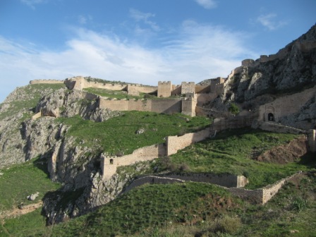
Acrocorinth

We decided to head next for Náfplio (Nafplion, Nauplion), on a secondary route driving south across the hills, which climbed to over 700m after the village of Ayionóri. The rocky hillsides were covered in low dry-stone terracing, creating hundreds of tiny fields. There were a great many of the animal fold shacks on these hills and in them we could see lots of very young lambs and kids. Once over these hills we were on the plains around Argos, where the orange groves stretched as far as the eye could see in every direction. It was obviously harvest time and lorries stacked high with crates of oranges trundled past us and unloaded at big distribution warehouses, where they were then loaded up onto even larger lorries for their journey to wherever. Perhaps one ended in your Christmas stocking!

Oranges and olives

Stone walls near Ayionóri

We liked Náfplio. The old town has a rather un-Greek air about it, and the shuttered stone townhouses on little squares and narrow pedestrian streets could easily be in Italy, or in old Venetian towns on the Croatian coast. Like much of the Peloponnese, Náfplio was indeed ruled by Venice for some time, and the fortress above the town is liberally plastered with the Venetian emblem, the lion of St. Mark, to prove it. It also has a number of well-preserved mosques, although all now serving other purposes such as the cathedral and the council chambers. This in itself is unusual in Greece where most traces of the 400-year Ottoman period were either destroyed or left to rot after Greek independence in the 1820s. The old town is largely given over to tourism these days but that can’t disguise its charms, and on the Sunday we arrived it was full of Greek weekenders who were gone by Monday morning. The harbour-front cafés made excellent places to sit watching the world and catching up with emails.


Náfplio – town

Life in Náfplio is easy for motorhomers, as the huge carpark by the dock provides almost unlimited free parking. We met the Belgian couple from Vólos again, and spotted French and Greek vans nearby. We stayed for two nights.

Náfplio – van on harbour

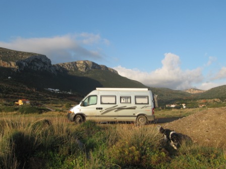
After Náfplio we continued down the east coast of the Peloponnese, to the old Byzantine port of Monemvasiá. The road at first hugged the coast, running high above the sea past endless coves and headlands, but after Leonídio it turned inland to avoid a wild area of particularly steep cliffs. We drove past mountain villages and over a high plateau covered in gorse-like scrub. The whole area seemed to be devoted to herding, and we camped up in sight of a collection of sheep and goat huts. The shepherds’ dogs were both wary and curious about us, and barked at us episodically through the night.

We passed a dump of old steam locomotives at Míli (Myli, Myloi)

We got to Monemvasiá on Wednesday 22nd December. At first you see only a huge flat-topped rocky outcrop sitting just offshore, connected to the mainland by a narrow causeway to the pleasant but nondescript village of Yefíra (Gefyra) opposite it on the landward side. However, as you continue around the side of the rock, you are suddenly confronted with a fortified stone wall, whose gate is wide enough for pedestrians only.

The rock of Monemvasiá

Inside the gate are the remains of a complete town, the first few streets lined by restored houses serving as hotels, tavernas or tourist shops, which gradually give way to shells of buildings and unidentifiable ruins. Monemvasiá had its heyday under the late Byzantine empire, until that was snuffed out by the Turks in 1453. After that it survived Turkish and Venetian rule and continued to be occupied until the early 20th century, by which time the newly-opened Corinth canal rendered a major port in this position superfluous, and it dwindled to the size of a village before mass tourism came along and suggested other uses for the abandoned houses.

Monemvasiá – lower town

We stopped for Wednesday and Thurday nights some 16km to the south of Monemvasiá, in the attractive little bay of Ayiós Fókas where the tarmac road finally runs out at a causeway to a little harbour chapel. It was a quiet spot, where the few houses had mostly a closed-for-the-season look, and we were able to cook over an open fire a couple of metres from the sea. We returned the next day for a second look at the ruins of Monemvasiá, and did the bulk of our Christmas food shopping in Yefíra at the same time. I (Rob) concentrated this time on Monemvasiá’s upper town, which sits above precipitous cliffs that loom over the more accessible lower town which most visitors see. It is a different, wilder world up here, where a vast jumble of ruined walls poke through the vegetation. Of all the buildings that once populated this plateau, only the Ayia Sofia church still stands substantially intact, having been restored in the 1950s. The rest seem to have been abandoned quite quickly after the expulsion of the Turks in the 1820s, when the military need for such a citadel disappeared.

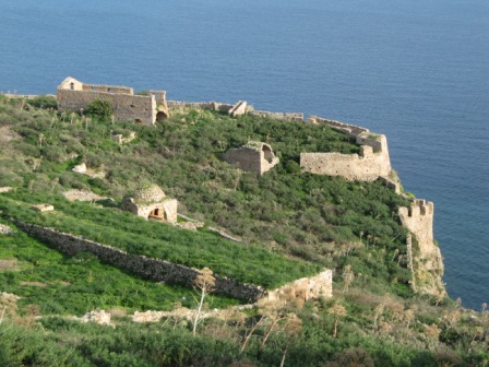
Monemvasiá – upper town

The weather took a remarkable turn for the better in the days before Christmas, and by Monemvasiá we were enjoying daytime temperatures in the mid-20s, as well as balmy nights that saw us opening skylights and throwing off the extra blankets that we’ve come to rely on these last few months. With the winter warmth came the more unwelcome side effect of flies and so the painstakingly hand-sewn (it took Lesley most of Norway) fly curtain for our panel van’s gaping side door, was once again velcroed into position The warm weather also meant we started eating a lot of salad again – and Greece is a good place for this as there is so much excellent fresh local veg on sale, plus the addition of great olive oil and feta cheese.

Ayiós Fókas camping spot

One of our aims for this trip was to be in Greece for Christmas and to have a bit of a break from travelling. Staying put in one place for more than two days really means we have to hook-up to electricity (oh how we wish we had solar panels!), and so we decided that of our Christmas break would be spent on a campsite near the pretty harbour town of Yíthio (Gythio, Gytheio, Gythion). We chose Yíthio partly because we liked the place two years ago and partly because we knew a couple of the campsites there were definitely open all year. We’d heard from an English family, the Pritchards, who were staying at one of them, Gythion Bay Camping, and said it was great, so we headed off in that direction.

Ellinikó village, Laconia

The journey from Ayiós Fókas to Yíthio turned out to be a very long 65 miles by the route we took across the hills. We wouldn’t advise it for anything big, as it climbs steeply with some sharp switch-back bends that saw our wheels slipping a bit. It was a wonderful drive though, which crossed the mountains of the Maleas peninsula through villages which seemed to tumble down the hillsides. Once down the other side, the land levelled out until we were driving across another area of flat, agricultural plains where numerous migrant workers of very Indian appearance, obviously Muslims by their clothing, were engaged in harvesting oranges.

Shipwreck on beach near Yíthio

We arrived in Yíthio by late afternoon on Christmas Eve. The numerous harbour-side restaurants looked inviting but they were for another day, and we drove on through until we found the campsite, which is one of several along the broad sweep of Mavrovoúni Beach. Christmas Day itself was a very low key affair, with none of the usual trimmings for Rob to get all bah humbug about. On Boxing Day evening we had far too much to drink with another Brit staying on the campsite, John, who intends to make his way to China at a leisurely pace on his motorcycle. Not being ones to learn our lesson we repeated the whole event two nights later and enjoyed our wide ranging conversations with an interesting guy.

Yíthio harbour

So that was it. Our aim to be in Greece by Christmas was fulfilled after 8 months of travelling. We think we’ll see in New Year at Yíthio and then slowly move round the bottom of the Peloponnese for most of January. After that it should be a ferry to Italy, where we have plans to meet family for a weekend in February, before we have to think about routes home which avoid cold or snow.

Mavrovoúni Beach

Happy New Year to all of you from Lesley, Rob and Charlie dog. XXX

Hristópsomo – Greek Christmas bread


Monday 20 December 2010

Greece 2 – Veryína to the Gulf of Corinth

8th to 18th December

We have a perfectly good Rough Guide to Greece. The fact that it was published in 1998 just means we now have the added interest of being able to note how places have changed in the intervening years. Take our destination of Veryína (Vergina), on Wednesday 8th December, where the village was then described as starting to develop with the advent of tourism, and listed two tavernas and two pensions. In late 2010 it proved to be quite a busy little place, with several open cafes, tavernas, pensions and a friendly little stellplatz, on which we spent two nights (with water and electricity - 6€ a night).


In 1977 archaeologists discovered the Royal Tombs of the Macedonian king, Phillip II, father of Alexander the Great, under a tumulus in Veryína. We arrived at the site’s gate around 2:30 p.m., just as it was closing for the day. It didn’t matter though, the sun was out, we had water and electricity to heat it - time to do some washing. Getting your washing done has to be one the biggest pains of being in a van. A washing machine is such a great thing when compared to a small sink and a couple of plastic bowls. In retrospect we shouldn’t have tried to tackle so much, as it took ages, and by the time we were hanging it out the sun was dipping behind the hills. The next morning we woke to heavy mist which forced us to bring the whole lot inside and drape it about our small living space. It took all day and a complex rotation system to dry it over the tiny 1000w oil-filled radiator, and even then two stubborn items hung about for a couple more days.
Veryina museum and a tomb entrance – we were not allowed to take photos so I’m afraid these are not ours

The well laid out museum and tombs were fantastic, despite the parties of bored Greek teenagers out to prove that education is wasted on the young. Some of the artefacts found are incredibly beautiful, especially the crowns of fine golden oak leaves and acorns, and silver dining sets designed to ensure that deceased royalty feasted in the afterlife in the style they had always been accustomed to. The miniature statuary and the painted friezes contained such lifelike human figures that they had us wondering why everything got a bit two-dimensional in painting in the Middle Ages. We also mused on the fact that so many of the world’s great treasures started off as tributes to someone truly awful. Phillip II was an aggressive, power-hungry conqueror, intent on carving out and securing the empire of Macedonia. In the context of those times you had to be like that to rule, but in admiring all the artefacts you can’t help thinking about the person they were dedicated to. Still, it must have been amazing to have been in the group of archaeologists who opened the first tomb and came across treasures beyond anything they could have hoped to find. More amazing is that these tombs, the richest ever found in Greece, survived the ages without falling prey to grave robbers, which was the fate of so many nearby tumuli.

Veryina museum treasures – again, not our own photos I’m afraid – but we wanted to show the beautiful treasures


Greece is just so green at this time of year, even by comparison with Bulgaria which lies just one mountain range to the north. Below 300m most trees still have their leaves, plus the bushes still have their foliage. Then there are all these olive trees, which are in the process of being harvested. It looks incredibly laborious. Spreading a big plastic sheet under a tree and more or less raking through the leaves, or trimming off whole branches, seems to take up a lot of spare time here.

It’s all looking green

We had originally thought how clean Greece looked compared to Bulgaria and Romania. The villages are generally neater, with newer houses of a rather uniform appearance, but there’s actually still a great deal of fly-tipping about. It’s not on the proportions of the rest of the Balkans, but every gully or ravine seems to have rubbish just slung down it. Do they not have proper rubbish dumps? It’s a shame when you see stretches of beautiful countryside covered in plastic and tin cans. Plastic bottles seem to be a real blight here, on roadsides, on beaches and just about everywhere you go. They really do need to be sold with hefty deposits attached to persuade people to recycle them. We’re doing our bit. We have several 2 litre bottles in the van filled with Greek wine.
I thought this showed how rubbish gets everywhere, but Rob assures me that these are offerings in the shrine!

Out in the countryside you see many rambling collections of jerry-built animal sheds where herds of goats, sheep, and even cows, are corralled when not out grazing, but Rob keeps bemoaning the absence of the clatter of horses’ hoofs, which we got so used to in the other Balkan countries. Obviously the sounds made by pick-up trucks and battered 4x4s just do not have the same effect.

Agri-shacks

We’ve been on the road for seven months now with barely a cough between us, but after visiting the Macedonian tombs we went down with our version of the Pharoah’s curse. Lesley was first, on the second night at Veryína, and was up every hour through the night with her head in a bowl. She slept in the passenger seat for most of the next day’s drive, and I (Rob) had my turn two nights later when we were camped near Vólos.

Mt Olympos views from route 74 near Ayios Dimitrios

From Veryína we took an inland route down through the province of Thessaly, passing to the west of Mount Olympus. It was an overcast day, and the tops were hidden in cloud although the snow on the slopes was clear enough. On the higher parts of the road, the outside temperature dropped to 0°C. By late afternoon we had reached Lárisa, the busy regional market town, but with the need for an overnight spot now pressing, we carried on a bit further then turned up a minor road towards the coast. We hadn’t quite taken into account the height of the hills to be crossed, or the minor-ness of the road, and found ourselves winding slowly ever further uphill as darkness, and the temperatures, fell. With the last light in the sky we found a secluded pull-in behind a disused workmen’s hut, as the indicator hit -2°C. We were buffeted by the wind all night, and it got to -5°C by dawn. It felt like one of the coldest nights so far. Who said we’d outrun winter?

The next morning at our overnight spot by Sklithro road – don’t worry, the graffiti is on the hut, not our windscreen

The next day, Saturday 11th December, saw us back at the coast by Vólos, and we drove around the bay to Agriá, which lies at the start of the Pílio (Pilion/Pelion) peninsula. The great view at sunset from our place by the sea did not prevent a chilly and windy night, and me (Rob) being up for half of it with my bout of sickness didn’t improve matters either. But it was a good place to lie in bed and recover on the Sunday morning, as the clear sky that had kept it cold led now to crisp and sunny views across the Gulf of Vólos.

Agriá beach overnight spot

It turned into a warm afternoon, and we managed to move a miniscule 7 miles along the coast, through a fertile landscape of orange groves and greenhouses to a small harbour that was sheltered from the wind. We were we settling down for the night when to our astonishment a Belgian motorhome drew up and parked beside us. This couple from Flanders were the first other foreign motorhomers – foreign in the sense that they were travelling, like us, outside their own country – that we had met since Bob and Wendy in Estonia nearly three months ago.

Harbour near Kato Gatzea - overnight spot

Neighbours!

Monday 13th started quite bright and it felt good to wake to coastal views once again. Being near the sea means being near fish and so the fishing rod was dragged out of its bag and into the light of day. Maybe it’s our Norwegian lures, or maybe we don’t know where or when to actually fish, but nothing has been caught so far. Watch this space… The sun didn’t hang around though, so we pushed on too, taking advantage of the market gardening in the area by stocking up on fruit and veg on our way back into Vólos. Here the crawling traffic and lack of parking defeated us, still delicate as we were, which is a shame as it looked like a nice town, with busy streets lined with palm trees and full of shops displaying Christmas decorations. We took the old, non-motorway route to Glyfa, where a ferry connects to Ayiókambos on the island of Evvia (also written Euboia – a good example of how crazy some transliterations of Greek names can be). On arriving in Glyfa it was obvious that the ferry was just about to leave, but we hadn’t got tickets. Rob started running back to the ticket office only to be shouted at in Greek to drive straight on. Cripes! We didn’t even know how much it was going to cost. We’d said we’d miss out Evvia if the tickets were too expensive. What the hell – we drove on anyway! Then were told to turn round, which was our first three point turn on the deck of a boat. It cost 19.70€, which didn’t break the bank, and within twenty minutes we were driving off onto our van’s first Greek island, albeit in the rain once again.

Evvia ferry - Glyfa to Ayiókambos

Evvia is the very long island that lies parallel to the mainland just above Athens. We headed down its western tip to Yiáltra (Gialtra), where there are supposed to be hot springs bubbling straight into the sea. We were blowed if we could spot them, despite keeping our eyes peeled for tell-tale signs of steam. The whole place looked shut up for the winter, though a few chimneys had smoke, so some people were obviously still around. Our next stop, Ayiós Yeóryios (Agios Georgios), looked much the same. Sleepy places can come up trumps with good, out of the way, spots to park up but we drove through with a sinking feeling that we weren’t going to find a decent spot for the night on this part of Evvia. We even resorted to setting ourselves a time limit again – ten more minutes and then we turn round and settle for something second best. I (Lesley) am a firm believer that if we stick at it “the right spot” will always turn up, and just as we were losing the light we found it at the tip of the island, on a sort of promenade alongside a pebble beach. There was a flat shrubby area where a few caravans, all shut up for the season, were permanently parked up and we slotted neatly into a space amongst them, from where we could see the bright lights of mainland and the distant motorway.

Evvia overnight spot on tip of Lihada pensinsula – you can’t see us but we’re on the left. Also, the village of Ayiós Yeoryiós

The sun returned the next day, revealing Evvia’s mountainous spine and providing a fine day to drive down the steep and rocky south coast. Another search again failed to spot the hot springs at Yiáltra, we even felt the sea this time for signs, but at the first real town, Loutrá Edipsoú (Aidipsou) a wrong turning took us onto the hillside above the seafront hotels, and just as the road petered out into a track, we noticed steam coming from the field below us. The hot spring water emerged from a pipe and flowed in a steaming delta down towards the buildings, seemingly unchanneled and uncollected. Apparently this town specialises in spa treatments (loutrá means ‘springs’), so the hot mineral water must emerge in more than one place.

Loutrá Edipsoú - hot springs and coast road to the east

By evening (which currently counts as 5pm, when the sun goes down) we were at Límni, a rather picturesque harbour village lying in a gap in the cliffs, whose seafront is accessed by narrow winding roads. They only just seemed adequate for a 6 metre long motorhome, although heaven knows, buses and delivery lorries manage it so we must be too sensitive about these things. A beautiful, and occasionally alarming, single-track road carried on southwards at the foot of the cliffs towards a convent, passing some wonderful stretches of secluded pebbly beach. The narrowness of both roadway and verge gave us no good places to park up though, and we ended up back in Límni where we settled down in a quiet spot on the seafront at the far end of the village.

Límni

One attraction of staying in a village was the chance to go out for a meal and enjoy the local cooking, but we learnt two important lessons that night. One, that not all Greek cooking is good, and two, that if you go to an empty restaurant on a Tuesday night in December you should not expect the best culinary experience. We knew things were not good when we attempted to order from the menu and were told that most of our choices were off. OK, we said, what is actually on tonight? The choice was of the ‘that, that and that’ type, and once we’d abandoned thoughts of fresh seafood, went for safe ‘keftedes’, meatballs that are usually grilled and though simple can be delicious. These ones were deep fried and tasted of nothing. Now, you can sympathise with them not wanting to start up a fuel-hungry wood barbecue when they are not expecting any custom, but in that case why open at all? The rosé wine and toasted bread were good though.

Big mirrors are an asset when reversing the van!

Límni was busy in the morning, with all the dozens of little shops open, and people out and about. By UK standards it would be a large village, but it supported at least five butchers and two bakers, three greengrocers/grocers and a fishmonger, and the small supermarket had not driven out the numerous general stores scattered around the narrow streets. I (Rob) dream of living in such a place.
Local produce – honey stall at Prokópi, the town was full of honey sellers

With the rain now back, we continued south on the main island road. It crosses two ranges of hills, but in the middle passes through a fertile inland plain where you would never know that you are on an island. About halfway lies the village of Prokópi, where we went to find the shrine-church of St John the Russian. You may not have heard of this saint, but he is apparently popular among Greek Orthodox believers, and the Russian Orthodox church has erected a shrine to him in Moscow in the post-communist years. John, or Jan, was a young Ukrainian soldier in the tsarist army who was captured by the Turks in battle in 1711, and spent the next 19 years as a slave in Cappodocia, in modern Turkey but then with a sizeable Greek Orthodox population too. As a slave, so the story goes, John stuck steadfastly to his Orthodox faith, and gained respect for his piety and good deeds. He performed his first miracle while still alive, a teleportation trick with an engraved plate, and his uncorrupted remains continued to sponsor miracles after his death. His mummified body was kept as a relic in a church at Prokópi in Cappodocia, and in 1923 it was brought here when the Christians of Anatolia were expelled in the ghastly ‘exchange of populations’ between Greece and Turkey, and New Prokópi was founded by the refugees on the island of Evvia. The body is still here, and forms the centrepiece of the large modern church, encased in a glass-topped silver casket. It is a grisly affair, with leathery brown skin over shrivelled limbs, wrapped in a colourfully embroidered satin gown and wearing a gold death-mask. It still attracts considerable devotion from people who pop in to kiss the casket and the icons, then go off to their daily business. Try as we might, this is something we find hard to understand.

Prokópi- John the Russian’s mortal remains, apart from one of his hands which is on Mount Athos, rest in this 1960s built church

We drove, through cloud again, over the central hills of Evvia. Once over the highest point at 600m, the cloud dissipated and we could see snowy peaks to our left. Ah, so that’s where winter was – on the east of the island. We rejoined the mainland at Halkída (Chalkida, Khalkida, Chalkis) where just a few metres separate it from Evvia, and the channel is crossed by a short bridge. This tiny stretch of water was known in ancient times as the Evripos and famed for its bafflingly frequent changes of direction as the tide grew higher on one or other side. I(Rob) stood on the bridge for a few minutes but the only surprising thing I saw was a bright blue fish about three feet long swimming westwards through the bottleneck.

Halkída – old mosque and Evripos channel

We headed north-west out of Halkída, through an almost continuous string of villages made up mostly of holiday/second home apartments and houses. Many of these looked very upmarket indeed and in the summer we guessed the area would be full of wealthy Athenians. We just wanted somewhere out of the wind though, and ended up at another harbour, so often a good place to overnight, at Drosiá, where we tucked in next to a large boat which was out on the shore for repairs. Its hulk saved us from the worst of the wind, and we woke on Thursday 16th December to more miserable weather, with low cloud and intermittent cold drizzle. No-one actually guaranteed that winter in Greece would be warm you know! We’re hoping that the Peloponnese might provide some higher temperatures. To get there we decided to take a cross-country route from the Aegean to the Gulf of Corinth, through Thíva, or ancient Thebes, which today is a normal Greek town with little to show for an ancient past and a name everyone has heard of but can’t quite think why. Crossing the next range of mountains on the old Athens main road we noticed what looked like frost on the fields. No, wait… surely it was a touch of snow? We stopped to take a picture of this rarity, only to find five minutes later that the landscape either side was completely blanketed in white and the edges of the road were piled up with sludge. We were back to outrunning winter again, but it wasn’t too much of a race for once over the summit the snow abruptly disappeared and the weather began to pick up.

Is it frost? No, it’s snow and we will outrun it!

At the turning to Porto Yermenó (Germeno) we got our first views of the Gulf of Corinth way below. The bay was dominated by the ruins of the ancient city of Aigosthena, which was built around the 4th century BC and occupied up to Byzantine times. A couple of towers still stand, along with long stretches of walls composed of massive blocks of stone. These are traceable right down to the shoreline, with some reconstructed segments rising imposingly high.

Gulf of Corinth and Aigosthena ruins at Porto Yermeno

We followed the small road around the south coast of the Gulf of Corinth for the rest of the afternoon, through a string of small closed-up resorts. However, the wind was fierce on this side of the bay and the many “no camping” signs left an uninviting impression, so we decided to look for a more sheltered spot to park for the night over the next small headland. Just as the light was fading we decided to try a signpost towards Lake Vouliagménis, which is in fact a near-circular sea inlet. It is very attractive, but was plastered with “no motorhome” type signs, so we then followed another sign to the ruins of Heraion, which turned out to be some attractively sited excavations just below the lighthouse-topped Cape Melangavi. The road was lined with nice flat areas in the scrub which made a perfect, sheltered, spot for the night. Judging by the number of old fires around we were not the first to camp here, and following their examples Rob set up the BBQ once more.

Cape Melangávi

We awoke on Cape Melangávi to crystal-clear views over the gulf, to a long line of snowy peaks to our north. The sun had returned and it was a lovely spot to while away a day, which we did, spending the whole of Friday 17th December here. I (Rob) cycled into the next village, Perahóra, for some shopping, and was again amazed by the number of food retailers in such a small place, giving me a choice of butchers and bakers once I’d visited the fishmongers. The freshness and quality of the food was impeccable.

Cape Melangávi panorama - north coast of gulf of Corinth

We walked down to the ruins of the Heraion in the afternoon. I say ‘the’ Heraion for it is just one of many temples to the goddess Hera, wife of Zeus. There was no proper explanation of the site so we basically know nothing about it, but it was beautifully located between the headland and the water, facing the mid-winter setting sun. From the rocks we could make out the Corinth Canal to our south, appearing as a bridge topped notch cut right through the low hills opposite.

Cape Melangávi - view of Corinth Canal  and Heraion ruins

We finished the day with a barbecue meal, with courses of fish, vegetables and meat all done over a wood fire. Not bad for mid-December.

Mealtime at Cape Melangávi